Home
* Contact * INDEX *
Current Issues * Priority Issues *
Reference Index * Selwyn's
Profile * Your
Comments
INTRODUCTION
Beneath the surface of the land
lies a tremendous resource that many of us depend on for our very existence, yet
often take for granted. This precious resource is ground water.
Ground water aquifers provide
water for almost half of the state's population and about 90 percent of its
rural residents. It is also an important source of water for community supplies,
industrial needs and agricultural uses.
Far North Queensland (FNQ)
has an abundant supply of ground water in a complex system of under-ground
aquifers. Unlike some parts of the country, which receive very little
precipitation, an abundance of annual monsoonal rainfall is constantly
replenishing FNQ ground water.
Although some areas of the
state have experienced problems with quantity and quality of ground water, these
problems have not yet proven severe. However, it is inevitable that future
growth will continue to place increasing demands on this precious resource. It
is critical to the future of the state that we strive to better understand the
nature of our ground water resources, to help to ensure that our activities
don't irreparably damage our supplies.
What Is Ground Water?
FNQ has a relatively abundant
supply of both surface water and ground water. Fresh surface water includes the
water in our rivers, creeks, streams and lakes. These sources make up the
aboveground portion of our total fresh water supply. The part that lies below
the earth's surface in saturated layers of sand, gravel or sedimentary rock, or
in fractures in crystalline rock is called ground water.
People tend to understand
surface water much better than they do ground water. We can see surface water.
We swim in it and fish in it. We can see that water levels decline during dry
weather and rise when rainfall is plentiful. We can also see the effects of
man-made pollution almost immediately.
On the other hand, ground
water is hidden. It is deep in the ground and is shrouded in many misconceptions
and myths.
For instance, some people
believe that ground water originates in some mystical, pristine place far
removed from man's influence. The fact is, almost all ground water found in FNQ
originates within the state's boundaries, and many bores withdraw water which
originates within a few hundred feet of the bore.
Many people also believe that
groundwater occurs in vast underground rivers or lakes. But with the exception
of underground caverns and solution channels in some limestone aquifers, ground
water almost always occurs in small pore spaces in layers of saturated sand,
gravel or sedimentary rock or in cracks and fissures in crystalline rock.
The Water Cycle groundwater
makes up part of the earth's water cycle or hydrologic cycle, which is the
continuous circulation of moisture and water on our planet. This cycle is in
constant operation, moving water from the earth to the atmosphere by evaporation
and back again to the earth's surface as precipitation, to produce stream flow
and ground water flow.
Of the water that falls to
the earth's surface in the form of rainfall, some runs off the surface, some
evaporates back to the atmosphere and some infiltrates into the ground. Part of
the water that moves into the ground is taken up by plant roots and re-enters
the atmosphere through transpiration. The rest percolates deeper into the earth
and becomes ground water. This process is called recharge.
Aquifers
The word aquifer comes from
the Latin words aqua, meaning water, and ferre, meaning to bear or
carry. Thus an aquifer is a water-bearing geologic formation that can yield
usable amounts of water. An aquifer may be a layer of gravel or sand, a layer of
sandstone or limestone, or even a body of massive rock, such as granite, which
has sizeable cracks and fissures.
An aquifer may be anywhere
from a few feet to several hundred feet thick. It may lie just below the earth's
surface or hundreds or even thousands of feet down.
Aquifer materials may be
classified as consolidated or unconsolidated rock. Consolidated rock (often
called bedrock) may consist of sandstone, limestone, granite or other rock.
Unconsolidated rock consists of granular material such as sand, gravel and clay.
The quantity of water a rock
can contain depends on the rock's porosity, the total amount of spaces among the
grains or in cracks that can fill with water. If water is to move through rock,
the pores must be connected to one another. If the rock has a great many
connected pore spaces big enough that water can move freely through them, it is
permeable.
Aquifers consisting of sand
or gravel contain relatively large interconnected spaces between particles and
will generally yield sizeable quantities of water. On the other hand, clay may
contain a considerable amount of water and yet the pore spaces are so small that
water cannot move freely between them. Therefore, clay layers tend to impede
water movement and are not productive aquifers. Some of the most productive
aquifers in FNQ consist of sedimentary rocks such as limestone, dolomite and
sandstone. These typically contain many solution channels and interconnected
pores, which hold water and allow it to move easily.
Crystalline rock, such as
granite, contains very little pore space and has very low permeability. However,
nearly all consolidated rock formations of this type are broken by cracks,
fractures or faults, which may enlarge over time. These cracks tend to hold
water and, when intercepted by a bore, will often yield usable quantities of
water.
In many areas there may be
multiple aquifers stacked on top of one another. These distinct layers of
water-bearing material are often separated by impermeable layers of clay or
rock, which prevent water from moving readily from one aquifer to another. These
impermeable layers are called confining layers or confining beds.
An aquifer, which does not
have a confining layer above it, is said to be unconfined. The upper surface of
the saturated zone in such an aquifer is referred to as the water table. These
aquifers occur in almost all areas of the state and are commonly called water
table aquifers.
In water table aquifers,
water may move readily from surface sources such as streams and rivers to ground
water and vice-versa. The water level in these aquifers fluctuates readily with
changes in weather patterns. An aquifer lying beneath a confining layer is
commonly called a confined or artesian aquifer. As the water flows beneath the
confining layer, the impermeable layer above it essentially traps it.
Consequently, the water in
the aquifer may be confined under pressure. When a bore is drilled into such an
aquifer, this artesian pressure will cause the water level in the bore to rise
above the point where the bore intercepted the aquifer. The level to which water
will rise into tightly cased bores from artesian aquifers is called the
potentiometric surface.
If a bore is drilled in a
low-lying area where the surface of the ground is lower than the potentiometric
surface, water will flow from the bore under its own pressure. Such a bore is
known as a flowing artesian bore.
Since artesian aquifers are
overlain by confining layers, recharge to the aquifer can only occur in places
where the confining layer leaks, is absent, or where the aquifer is exposed at
the ground surface. These areas are known as outcrop areas or recharge areas.
Ground water is always moving
by the force of gravity from recharge areas to discharge areas. Contrary to
popular belief, ground water movement is generally very slow, typically only a
few feet per year. However, in more permeable zones, such as solution channels
in limestone or fractures in crystalline rock, it may move as fast as several
feet per day.
The force of gravity moves
water toward areas of lower elevation. Ground water, particularly from the water
table aquifers, typically discharges into streams, lakes and wetlands. Where the
water table intercepts the ground surface, water can discharge, forming a
spring.
Because of differing geologic
features and landforms in varying parts of FNQ, there are substantial
differences in ground water conditions from one area to another. These features
affect ground water quantity and quality.
Water table aquifers are
present in each of the physiographic areas. They are usually unconfined and are
used for domestic and livestock supplies in most areas. Shallow bores tapping
the water table aquifer are especially prevalent in rural areas where they are
often used for domestic supply and livestock watering.
Crystalline rock aquifers are
used primarily for private water supplies and livestock watering. It is commonly
believed that groundwater in this part of the state is not sufficient to supply
such uses as community supplies and industry. Consequently, large water users in
FNQ have relied primarily on surface water.
In recent years, however,
systematic bore-siting techniques have produced high-yielding bores (greater
than 500 litres/min.) on a regular basis. Because surface water sources have
been pushed to their limits in some areas, several studies are now under way to
evaluate whether the use of groundwater can be increased in this region,
particularly for community supplies.
Because of the increased use
of ground water over the past few decades, there is increasing concern about
declining ground water levels and whether water is being removed faster than it
is being recharged.
Several factors cause ground
water levels to fluctuate. These levels naturally rise and fall because of
seasonal patterns of ground water recharge and storage.
In FNQ, ground water levels
tend to be highest in the winter and lowest in summer. In late spring, summer
and early autumn, evaporation and transpiration by plants use up most of the
water that would otherwise recharge the aquifer. At the same time, the aquifer
is discharging water into streams, springs and bores.
A seasonal decline in ground
water levels results. In the late summer, winter and early spring, most plants
are dormant and evaporation rates are low. Consequently, rains during this time
of year tend to saturate the soil, stream levels rise, and ground water recharge
occurs, resulting in water level increases.
Longer-term changes in ground
water levels may occur because of climate and pumping changes. Less ground water
recharge will occur during dry years than in wet years. Several years of below
normal rainfall will typically result in a gradual decline in water levels.
Ground water levels can also
be affected by pumping from bores. When water is pumped from a bore, the water
level in the bore is drawn down, forming a cone-shaped depression on the water
surface. This cone of depression is maintained as long as the bore is pumping
but is usually localized and does not affect other bores in the area.
However, when several
high-capacity bores are pumping in the same vicinity, the cones of depression
may overlap and cause a general lowering of the water level in an area. When
this happens during a time of dry weather, the water level may drop to the point
that shallower bores in the area go dry and the water level drops below the pump
inlet in others. When this happens, even though the situation is usually
temporary, it creates a great deal of concern about the use and allocation of
our ground water resources.
FNQ
All ground waters in FNQ
contain naturally occurring minerals in varying concentrations. It is not
unusual for ground water to contain some minerals in high enough concentrations
to cause problems with staining of plumbing fixtures and laundry, scale
formation or objectionable tastes and odours.
Other water quality problems
have been detected by various state agencies, but these have been relatively
isolated and limited to small areas.
Ground Water Protection
Protecting ground water from
the effects of man's activities should be a major priority in order to preserve
this valuable resource for future generations. Ground water, as a rule, moves
very slowly. Once contaminated, an aquifer is very difficult (if not impossible)
to clean up. It may take decades or even generations for nature to cleanse a
contaminated aquifer.
Some potential sources of
ground water contamination include:
�
Septic tanks
�
Solid waste landfills
�
Leaking underground storage tanks
�
Municipal and industrial wastes
�
Animal wastes
�
Agricultural fertilizers and
pesticides
Any of these contamination
sources can pollute ground water if not managed properly, but all are of special
concern in those areas identified as major ground water recharge areas. In the
future, these ground water recharge areas may warrant special protection in
order to preserve the quality of the FNQ ground water.
Besides man's ability to
create pollutants, his activities may also create situations, which make
contamination of ground water more likely. For instance, over pumping from bores
in coastal areas may cause salt-water encroachment. Over pumping may also cause
sinkholes to form in some areas. These sinkholes may breach the confining layer
above an aquifer and allow contaminants from the surface to enter the aquifer.
Bores, if not properly
constructed, may allow water from the surface to carry contaminants into the
aquifer, or they may allow water from a shallow, contaminated aquifer to mix
with water in a deeper aquifer. Old, abandoned bores and agricultural drainage
bores, if not filled, may also serve as conduits to allow surface contaminants
to enter the aquifer. A particular risk is incurred when these old bores are
used as disposal sites for household garbage, pesticide containers or other
waste products.
Fortunately, at present there
have not been any cases of widespread man-made contamination of any of the major
aquifers in FNQ. Where contamination has been detected in bores it has typically
been attributed to sources near the bore site, often immediately adjacent to the
bore.
FNQ ground water is one of
our most precious resources and every effort should be made to preserve the
integrity of this important commodity for now as well as for future generation.
RETURN TO: INDEX
Home
* Contact * INDEX *
Current Issues * Priority Issues *
Reference Index * Selwyn's
Profile * Your
Comments
.
AQUIFER RECHARGE
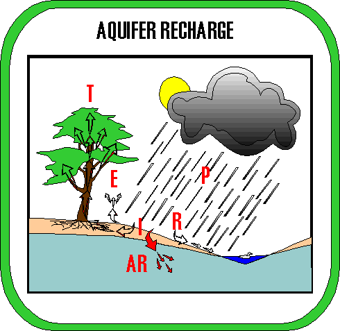
|
Precipitation,
Runoff,
Infiltration,
Evaporation,
Transpiration,
Aquifer
Recharge
|
What is an aquifer?
An aquifer is a body of geologic material that can supply useful quantities of ground water to natural springs and water wells.
What is aquifer recharge?
Aquifer recharge is the process by which rainwater seeps down through the soil into an underlying aquifer. There are many natural processes that determine how much rainwater actually reaches and replenishes an aquifer instead of being evaporated, consumed by plants and animals, or simply running off the ground surface into streams, rivers, lakes, and oceans.
Why is important to map aquifer recharge?
The protection of our water resources is an important for everyone in the State concerned with the quality and availability of clean drinking water. Previous water conservation and supply programs have proven to be insufficient for adequately protecting our drinking-water supplies. About half of the water used by humans for daily living is extracted from the ground. Therefore it is important to identify those parts of the State where our ground water is most likely to be replenished so that we can attempt to protect these vital resources from pollution and any land-use practices that will decrease the quality and availability of clean water.
How to map aquifer recharge areas?
The method uses rainfall data from climate-monitoring stations, maps showing how the land surface is currently used (residential, agricultural, commercial, wooded, pavement, etc.), what kind of soils occur at the earth's surface, and the extent of wetlands
(creeks, streams, rivers, lakes, marshes, and bogs). These data are combined using scientific methods to determine how much ground water is available in any particular area for recharge to the local aquifer. How much of this water will actually make it into the aquifer is also predicted based on how much water can usually be pumped from water wells drilled into the aquifer.
RETURN TO: INDEX
Home
* Contact * INDEX *
Current Issues * Priority Issues *
Reference Index * Selwyn's
Profile * Your
Comments
ATTRIBUTES
OF GROUNDWATER